FEMA Flood Maps May Be Revised in Ford City
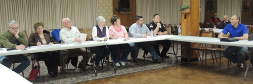
Gibson-Thomas Engineering’s Doug Siler informed a majority of Ford City Borough Council members at their monthly business meeting last night that he hopes local documents will help FEMA change floodplain maps and save taxpayers hundreds of dollars.
by Jonathan Weaver
About six weeks ago, a majority of Ford City residents were surprised to find out how much they needed to pay for flood insurance.
New floodplain maps were issued by the Federal Emergency Management Agency effective February 17, but Gibson-Thomas Engineering’s Doug Siler had some hope for about two dozen local residents Monday evening.
“We’ve had some discussions with FEMA since then. Unfortunately, we couldn’t stop the maps from becoming effective, (but) we’re looking to do what we can to get the flood maps revised again, Siler said.
“The original course of action we thought was that we needed to get this high ground along the river certified as a levee, which there are a lot of requirements that would require a lot of money to just do the engineering – not to mention any capital improvements needed to bring this levee into full certification.
“It could be hundreds of thousands (of dollars) in engineering costs and millions (of dollars) in capital improvement cost. (But), they now say the Borough does not need to fully certify this ground here as a levee anymore – they just want to see that the interior parts of the borough will be protected from local flooding with your storm collection systems and the pump stations,” Siler said.
Siler – who attended a Borough meeting in December to answer resident questions - will work with Council members to provide FEMA information to take a majority of residences out of the floodplain before updating storm water infrastructure and drainage.
“Right now, we are just in an information-gathering phase trying to see what information we have on the pump stations and the collection stations we can give to them,” Siler said. “We want to try to be as expedient as possible to try and get this done. Obviously, time is of the essence here.”
Borough Council President Carol Fenyes said that the Borough’s Planning Commission has done “quite a bit” of information gathering already.
“We’re going to try to do as much as we can to present (Siler) with the information to keep engineering costs for the Borough down,” Fenyes said.
Last summer, the Borough submitted an application for flood mitigation grant funds. The Latrobe-based firm will follow up on the grant application.
“I can’t say for sure FEMA’s going to remap, (but) if we satisfy them with the information they’re requesting, we trust they’ll revise the maps,” Siler said. “This is a much-more positive step than we initially thought.”
Siler did not have any information regarding refunding if the maps are changed and directed residents to their lending agencies.
The initial flood insurance rate map for Ford City Borough became effective in May 1987.