Angry Residents Challenge FEMA Maps While Council Sits Idle
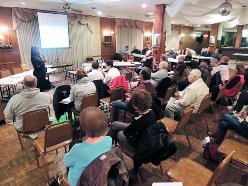
Senior Engineer Nikki Roberts describes the new digital flood insurance rate maps to dozens of Ford City residents last night before Borough Council conducted business.
by Jonathan Weaver
Each individual home or business owner in Ford City is facing a several-hundred dollar per month flood insurance bill after new maps were released by the federal government.
But, residents contend an Allegheny River levee has protected residents before and should again despite the government’s current statistical analysis.
Last night, FEMA (Federal Emergency Management Agency) Senior Engineer Nikki Roberts and Outreach Specialist Dave Bollinger met with concerned residents during the first hour of Borough Council’s monthly Council meeting to answer questions and address their concerns.
While they encouraged residents to contact local banks or insurance carriers about the new mandatory policies, most residents were not able to purchase the flood insurance since the new Digital Flood Insurance Rate Maps are not effective until February 17.
“Anybody who doesn’t have a federally-backed mortgage has no mandatory reason under the law to have flood insurance,” Bollinger said. “It’s a good idea to keep it, but you don’t have to have it if you don’t have a federally-backed mortgage.”
The flood insurance also carries along with it a $25 surcharge for residents and a $250 surcharge for businesses.
While a resident contended the extra insurance mandates would “bankrupt” the small municipality, one woman exemplified this by asking how she could pay for six properties that she maintains.
Congress directed FEMA to conduct an affordability study – which caused Bollinger to sympathize with the community.
“From what I see, this is very expensive for a landlord, very expensive for a homeowner. My opinion is I don’t know if this is sustainable,” Bollinger said. “The impacts on small businesses are greater – the $250 surcharge plus the increase of 25 percent for most businesses is really a difficult deal.
“We don’t want to see Ford City go under,” Bollinger said. “I understand Ford City’s heritage in glass making – it’s important and part of history. We should do everything we can to sustain it.”
Bollinger explained residents can save money through a preferred policy, a community rating system with outreach events to get residents informed on flood insurance, or even FEMA grants to elevate or move one’s home or higher deductibles.
But, a substantial savings would come if the current levee is accredited.
“In order for a levee to be accredited, there are a lot of steps you have to go through,” Roberts said. “But, at the same time, there are pumping system(s) in that area and, if we get some more information from the community, there may be an ability to change it if those pumps have been maintained.
“It’s an arduous process.”
Residents who purchase flood insurance but later prove they are not in the floodplain will receive a refund. However, informational analysis will take a few months depending on the number of appeals.
Still, Engineer Ron Olsen knows the levee has protected the town from several emergencies since 1887.
“It’s been tested with 100 year storms,” Olsen said. “(The new maps are) a huge problem for us, and we need to figure out a way to get out of this thing.”
Councilman Marc Mantini said the appeal process will be expensive but residents and elected officials should be proactive – including by contacting State and federal legislators.
“This has to be appealed because it will cost the taxpayers, lessen the property values and if somebody’s going to build, they’re not going to build in these valley communities,” Mantini said.
Borough Manager Eden Ratliff was glad the dozens of residents attended the meeting to address their questions.
Nevertheless, a majority of Borough Council authorized Council President Carol Fenyes to sign the new floodplain ordinance because of next week’s deadline.
Insurance carriers and ways to keep the community sustainable at floodsmart.gov
Preliminary maps – a compilation of all Armstrong County’s municipality maps into one set - were first distributed in June 2010 and a community meeting was held a month later.
However, revised preliminary maps – which can be overlaid on other digital data or geological maps, and allow residents to view their properties in real-time - were distributed three years later
“With the new DFIRM, we have better base maps – with ortho-photography we got from PAMAP, as well as new terrain data we got from PAMAP to make accurate representations of the special flood hazardous areas that we have now,” Roberts said.
Out of the 45 Armstrong County municipalities studied, 13 were given a new study report – those that were previously in Zone AE.
The four hurricanes and Hurricane Katrina that struck Florida in 2004-05 put the country $18 billion in debt and made the former flooding system unsustainable.
In other business, council members also adopted the revised 2016 budget and tax ordinance advertised during the past few weeks.
Both actions – which do not include any tax increase or decreases as compared to the 2015 budget - were passed by a 5-1 vote, with Councilwoman Kathy Bartuccio in opposition.
Bartuccio said she would have liked all six elected representatives to be a part of the budget process instead of the three-person Finance Committee.
Council Vice-President Tyson Klukan said that committee went through the financial plan “tooth and nail” and that changes were not drastic compared to the proposed funding plan passed by the previous Council.
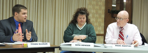
Councilmen Tyson Klukan and Marc Mantini encouraged residents to be proactive about the flood insurance rates even though the deadline to purchase is only about a week away.